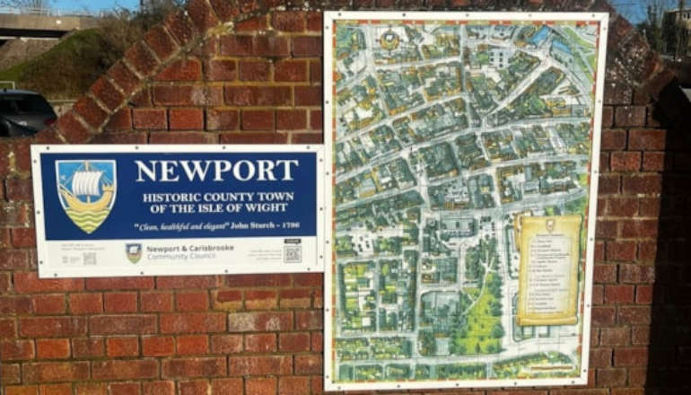
Heritage Action Zone funding from Historic England has given Newport and Carisbrooke Community Council’s Shaping Newport project the opportunity to install additional maps of Newport around the town at various entry points.
The funding was used to install five more maps last week, following on from the first map installation which was funded by the Isle of Wight Chamber and installed in 2019.
There are now six town maps, located at Lord Lois Library, Newport Bus Station, Chapel Street Carpark, Post Office Lane and Quay Street.
The map was created seven years ago by Alan Rowe and took six months to design.
It highlights key locations in the town, like notable buildings including Newport Minster and the Guildhall, al fresco dining spots and independent shops and was produced by local business A.J Wells.
There is an audio overview available, developed by local charity Sight for Wight, and an online version is hosted on the Newport and Carisbrooke Community Council’s website
These are accessed via a QR code printed on the maps.
Another QR code will take you to the Historic Newport Walks website, where you can access free historic walking trails around the town.
Councillor Julie Jones Evans, cabinet member for Economy, Regeneration, Culture and Leisure said:
“Seeing this beautiful map now in 6 locations around the town, not only is useful for visitors but is also public art.
“It’s beautifully illustrated by Alan Rowe and printed in lasting high-quality enamel by King's Award for Enterprise recipients A.J. Wells who are based in the County Town.
“Having the opportunity for funds from Historic England to produce 5 updated versions was something to be grabbed with both hands. Thanks also to Shaping Newport for making this happen.”


 Ningwood Hill Electricity Pole Crash Leads To Resident Evacuation
 Isle Access Announces New Trustees And Focus On Accessible Cycling
 Isle of Wight Ambulance Service partners with Hampshire and Isle of Wight Air Ambulance to elevate paramedic training and patient care
 County Hall Backs Motion To Support Isle Of Wight Farmers
 Wight Aid Helps Footprint Trust Boost Energy Savings
 Isle Of Wight CAMRA Pub And Beer Of The Year 2024 Winners Announced
 Have You Seen Missing Sarah Watson, 56, From Ventnor?
 Newport Youth Hub 'Proving Very Effective' Says Council Leader
 Kilometres-Long Underground Cable Could Be Installed Beneath Farmland
 Isle Of Wight MP Joins Forces With Digital Poverty Alliance For Local Device Donation Drive
 Newport Energy Hub Supports Utilita’s Renewed Pride365 Pledge
 Island Roads Weigh In On Village Tea Room Plans
 Bid To Construct Boat Store On Picturesque Island Seafront Met With Opposition
 Village Harbour Could Get New 19.7 Metre Houseboat With 27 Solar Panels
 Firefighters Come To The Rescue After Two Women Stuck In Mud In Seaview
 Silver Service For Frank As Islander Secures Place At World Bench Press Championships
 Island Duo Launch Science-Based Planner to Help Runners Stay Motivated
 Isle Of Wight Seaside B&B Could Be Converted Into House
 Half Million-Pound Floating Bridge 2024 Losses Revealed


